Guatemala’s rugged landscapes offer adventurers a glimpse into the raw power of the Earth, and few experiences capture this better than trekking some of its awe-inspiring volcanoes, often dubbed “The Ring of Fire”.
From the smoldering craters of Pacaya to the breathtaking summit of Acatenango overlooking the erupting Fuego, each climb is a journey through dynamic terrain, lush forests, and surreal volcanic vistas.
In this guide I will take you through five of Guatemala’s must-visit volcanoes, each with its own unique challenges, rewards, and stunning vistas. Whether you’re seeking a challenging ascent, the thrill of witnessing live eruptions, or simply panoramic views of the highlands, this guide will help you plan the ultimate volcanic adventure.
The best time of year to visit Guatemala, if you’re planning on volcano trekking, is November to April. This is the dry season, although as with any mountains/volcanos, there’s no guarantees dry weather is what you’ll get, so make sure you’re prepared for all weather!
Check out my Through The Lens post here!
Volcano 1 – Pacaya

Elevation – 2,552 m.a.s.l. (8,373 feet).
Hike Duration – 1.5 to 2 hours up, 1 hour down.
Difficulty –
Pacaya is one of Guatemala’s most active and accessible volcanoes, making it a top destination for adventurers looking to witness volcanic activity up close.
Located just an hour from Antigua, Pacaya offers a relatively easy hike with breathtaking views, lava fields, and even the chance to roast marshmallows over geothermal vents. And to top it all off, you can run down it’s scree slopes on your descent, which is great fun, and hopefully gives you some amazing photos.
How to Get There
Pacaya is located about 25 kilometers (15 miles) southwest of Antigua. You can reach the trailhead in San Vicente Pacaya by:
Tour Shuttle – Most tour companies in Antigua and Guatemala City offer guided hikes with round-trip transportation.
Private Transport – Hiring a driver or taking a taxi for a more flexible schedule.
Public Bus – Take a bus from Antigua to Escuintla, then a local bus to San Vicente Pacaya.
The Hiking Route
- Starting Point – San Vicente Pacaya
- The hike begins at the park entrance, where you pay a Q50 ($6.50 USD) entrance fee.
- Local guides are required for Pacaya. These can be hired at the park entrance if you’re going solo without a tour company.
- The Ascent
- The trail is a mix of dirt paths and volcanic rock.
- It starts with a moderate incline through lush forest, gradually opening to barren lava fields.
- Horses are available to rent if you need assistance.
- Lava Fields & Marshmallow Roasting
- While lava flows aren’t always visible, you’ll find steam vents where you can roast marshmallows.
- The terrain is rocky and sharp, so be careful and make sure you’re wearing sturdy hiking boots!
- Summit Views & Descend
- The final stretch offers panoramic views of nearby volcanoes Agua, Fuego, and Acatenango.
- After enjoying the scenery, head back down the same route, or go for a run down the scree slopes.
Two Top Tip
When running back down the scree slopes, make sure to plant your heels into the rocks to give you stability and use trekking poles if you’re not too confident.
You’ll also get covered in dust and your boots will fill with rocks (unless you happen to have gaiters on). Make sure to stop and empty your boots out before continuing your descent.
Volcano 2 – Acatenango

Elevation – 3,976 m.a.s.l. (13,045 feet).
Hike Duration – 5-6 hours up, 3-4 hours down.
Difficulty –
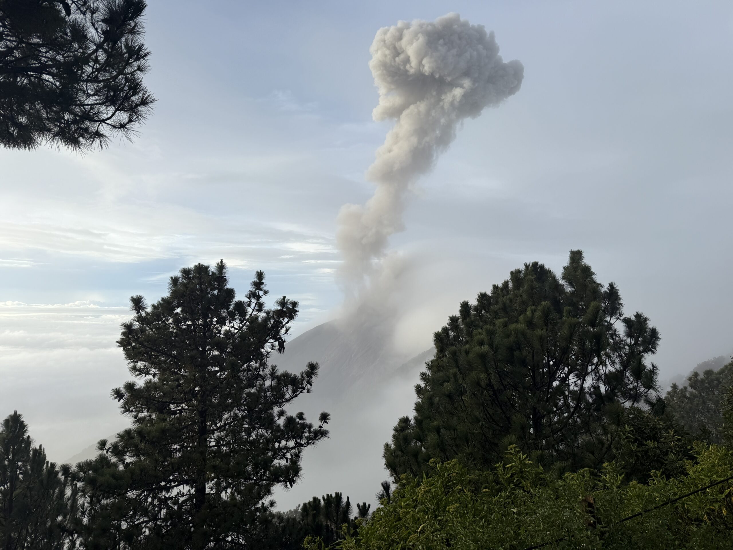
The famous postcard volcano of Guatemela. Acatenango. Cimbing Acatenango offers hikers a front-row seat to the explosive eruptions of its neighbor, Volcán de Fuego. A challenging overnight trek, due to the high altitude and cold night, takes you to 3,976 meters (13,045 feet), where, weather allowing, you’ll witness lava eruptions lighting up the night sky every 15-30 minutes!
How to Get There
Acatenango is located about 1.5 hours from Antigua. The starting point is in La Soledad, which can be reached by:
Tour Shuttle – Most hikers go with a guided tour from Antigua.
Private Transport – Hiring a driver or taking a taxi.
Public Bus – Take a bus to Parramos, then a local truck or tuk-tuk to La Soledad.
The Hiking Route
- Trailhead – La Soledad (2,400m)
- Pay the Q50 ($6.50 USD) park fee before starting.
- Local guides are required, again, these can be hired at the park entrance if you’re going solo without a tour company.
- Forest Section (1.5-2 hours)
- Begins with steep farmlands before entering a dense cloud forest.
- High Alpine Zone (2-3 hours)
- Steep switchbacks with volcanic gravel.
- Temperatures begin to drop as your altitude increases.
- Base Camp (3,600m)
- Where most hikers spend the night in tents or shelters.
- Incredible views of Volcán de Fuego erupting every 15-30 minutes!
- Final Summit Push (45 minutes-1 hour, pre-dawn)
- A steep, sandy ascent to the crater for sunrise.
- 360° views of Guatemala’s highlands and nearby volcanoes.
- Descent (3-4 hours down)
- Steep but quick return to La Soledad.
Two Top Tips
Bring plenty of layers to stay warm. It can get below 0C degrees at night, and you’ll be stood around outside wathcing the eruptions. As incredible a campfire as an erupting volcano might be, you won’t be feeling any heat from that lava.
The winds can also blow the ash and fine debris over the your campsite, so be mindful and don’t look up if it does!
Volcano 3 – Chicabal

Elevation – 2,712 m.a.s.l. (8,898 feet).
Hike Duration – 1.5-2 hours up, 1 hour down.
Difficulty –
Chicabal is a sacred Maya volcano famous for its mystical crater lake, often shrouded in mist. Unlike Acatenango or Pacaya, this hike is more about spiritual beauty than lava and eruptions. Located near Quetzaltenango (Xela), it’s a peaceful escape into nature and indigenous traditions.
How to Get There
Chicabal is located 20km from Xela, in San Martín Sacatepéquez. To get there:
Tour Shuttle – Guided tours available from Xela.
Public Transport – Take a bus or minivan to San Martín, then hike or take a pickup truck to the trailhead.
Private Transport – Drive to the park entrance for a quicker start.
The Hiking Route
- Trailhead – Park Entrance (Q50 fee)
- A mix of dirt roads and lush cloud forest.
- Steep Climb (1-1.5 hours)
- The steepest section, gaining elevation quickly.
- Mirador (Lookout Point)
- Offers an incredible view above the lake before descending to it.
- Stairs to the Lake (20 minutes)
- A steep staircase leading to Laguna Chicabal, a sacred Maya site.
- Swimming is not allowed, as it is a place for ceremonies.
- Return to the Trailhead
- Either hike back or take a pickup truck down.
Two Top Tips
Bring some lunch, or at least loads of snacks. The lake is beautiful place to just relax, take in the views and have a little bit of a picnic. Remember to pack out all your rubbish though!
There is also a football pitch at the trailhead, makes for an incredible place to have a kickabout if you’ve got the energy after the hike.
Volcano 4 – Tajumulco

See my full guide for climbing Tajumulco here!
Volcano 5 – San Pedro

Elevation – 3,020 m.a.s.l. (9,908 feet).
Hike Duration – 3-4 hours up, 2-3 hours down.
Difficulty –
San Pedro Volcano rises above Lake Atitlán, offering one of the best panoramic views in Guatemala. The hike is challenging but rewarding, with breathtaking scenery of the lake and surrounding volcanoes.
How to Get There
San Pedro Volcano is located near San Pedro La Laguna, on the shores of Lake Atitlán. To get there:
From San Pedro – Tuk-tuks can take you to the park entrance.
From Other Towns on the Lake – Take a boat to San Pedro, then a tuk-tuk.
From Antigua/Xela – Take a shuttle to Lake Atitlán, then a boat.
The Hiking Route
- Trailhead – San Pedro Park Entrance (Q100 fee)
- The hike begins at 1,800 meters and quickly gains elevation.
- Steep Climb (2-3 hours)
- Dense forests, winding switchbacks, and occasional resting spots.
- Mirador (Lookout Point, 2,500m)
- A great spot to rest and take photos of the lake.
- Final Push to the Summit (30-45 minutes)
- The summit offers awe-inspiring views of Lake Atitlán, Tolimán, and Atitlán volcanoes.
- Descent (2-3 hours down)
- Steep but easier on the way back.
Two Top Tips
This hike is definitely the hottest and most humid of the five, so bring plenty of water (and maybe even a little celebratory beer if this is the final volcano of your trip!).
Like pacaya this is another fun volcano to run down. A lot of the trail consists of paths made with old tyres, which feel great underfoot and can make for a really quick descent.